Showing posts with label Smart Cities. Show all posts

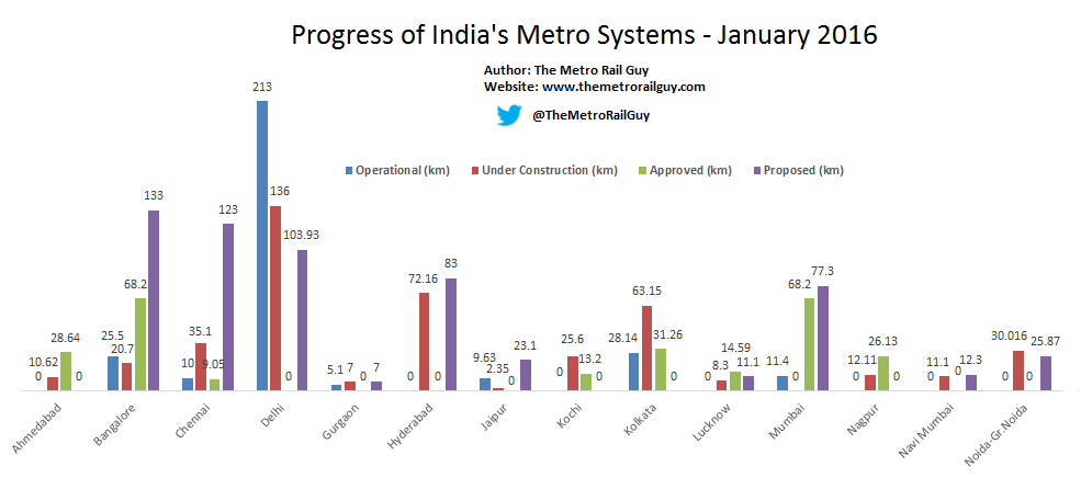
Snapshot of How India’s Metro Systems Stack Up With One Another

Snapshot of How India’s Metro Systems Stack Up With One Another

link to previous chart: January 2016
Note:
• In the interest of space, only under construction projects have been included above. Besides the above cities, metro projects have been approved by different state governments’ cabinets in Pune, Indore, Bhopal, Kanpur, Varanasi, Patna, Guwahati, Vijayawada – Amravati, Kozhikode and Trivandrum.
• Under Construction includes those section of lines for which contracts have been awarded and machinery/men have been mobilized on-site. For instance, a 10.39 km section, from Lokmanya Nagar to Jhansi Rani Square, in Nagpur for which piling work started in December 2016 has been included. On the other hand, sections of Kolkata’s metro lines which have been awarded for construction years ago, but have seen no ground-work, have been allocated to the approved column.
• Approved includes sections of lines which have at least been approved by the state government’s cabinet.
• Proposed includes upcoming lines which have been announced by the state government or local development agency. Their routes & distance are likely to be revised by the time their Detailed Project Report is created and approved. For instance, Delhi’s 140 km proposed figure includes the 105.93 km Phase 4 project (within Delhi) as well as other lines proposed by the Haryana and UP governments in Gurgaon and Ghaziabad. Bangalore’s 102 km figure includes the 17 km SilkBoard – KR Puram line (Phase 2A) as well as the Phase 3 project.
• The ‘Delhi’ label includes the entire Delhi Metro network which extends beyond Delhi’s borders into Ghaziabad, Noida, Faridabad & Gurgaon. The ‘Gurgaon’ label includes the line operated by Rapid Metro Rail Gurgaon (RMRG) while ‘Noida’ includes the line being implemented by the Noida Metro Rail Corporation (NMRC).

Hyderabad Metro

Hyderabad Metro – Information, Map & Updates


Introduction
The Hyderabad Metro Rail (HMR) system is an urban Mass Rapid Transit System (MRTS) that is being built to serve Hyderabad, the capital of Telangana. Construction for its 72 km first phase on the Public-Private Partnership (PPP) model started in April 2012 by L&T Metrorail and is expected to be completed in 2019 (est.). Although Phase 2’s new lines & extensions have been announced, it is likely to be modified by the time construction begins in 2019.

Key Figures

Operational: 0 km | Under Construction: 66 km | Approved: 6 km | Proposed: 83 km
Currently the 72 km Phase 1 is under construction of which the Nagole – Mettuguda (8 km) section of the Red line and the Miyapur – SR Nagar (10 km) section of the Green line are expected to open in 2017-2018 as soon as the state government & L&T agree to start operations. Phase 2 is currently in the planning stage..

Future Network: Phase 1-2

The embedded maps below can be zoomed into!
Key for map below: Phase 1 (Under Construction) | Phase 2  (Planned) 

Kochi Metro

Kochi Metro – Information, Map & Updates

Introduction
The Kochi Metro system is an urban Mass Rapid Transit System (MRTS) that is being built to serve Kochi, the commercial capital of Kerala. Construction for its 25.12 km Phase 1A from Aluva to Pettah with 22 stations started in June 2013. On June 17, the Prime Minister of India inagurated a 13.2 km section, from Aluva to Palarivattom, and commercial operations commenced 2 days later on June 19.
In 2014, a 1.92 km eastward extension to Tripunithura from Pettah was approved to be included in Phase 1. Construction on it will begin once road widening along the route is completed. Phase 1B of the project includes a new spur line from Jawaharlal Nehru Stadium to Infopark II in Kakkanad. The project was approved by the state government in May 2015 and construction work is expected to begin in 2017.
Various announcements of what Phase 2 will look like have been made, but detailed planning for it is yet to begin.

Key Figures

Operational: 13.2 km | Under Construction: 12.412 km | Approved: 1.92 km (Phase 1) and 11.2 (Phase 1B)
Phase 1A: Aluva – Tripunithura:  27.04 km, 24 stations (operational & under construction)
Phase 1B: JLN Stadium – Infopark II: 11.2 km, 10 stations (approved)
The embedded maps below can be zoomed into!

Operational Network:

Future Network: Phase 1A & 1B

Stations on Line 1:
Phase 1A: 
Aluva, Pulinchodu, Companypady, Ambattukavu, Muttom, Kalamassery, Cochin University (CUSAT), Pathadipalam, Edapally, Changampuzha Park, Palarivatom, JLN Stadium, Kaloor, Lissie, M.G. Road, Maharaja’s College, Ernakulam south, Kadavanthra, Elamkulam, Vytila, Thykkoodam, Pettah, SN Junction & Tripunithura
Phase 1B: Palarivattom Bypass, Chembumukku, Vazhakkala, Kunnumpuram, Kakkanad Junction, Kochi SEZ, Chittethukara, Rajagiri, InfoPark I, and InfoPark II

List of Major Contractors

ContractDetailsContractor
GCGeneral ConsultantDMRC
DDCDetailed Design ConsultantEgis India
KRS-175 Coaches (Rolling Stock) & Signalling SystemAlstom India
KS-1Signalling, Train Control & TelecommunicationAlstom India
KS-2Automatic Fare CollectionAxis Bank
KC-02Construction of viaduct & 6 stations from Aluva – KalamasseryLarsen & Toubro
KC-03Construction of viaduct & 6 stations from CUSAT – JLN StadiumLarsen & Toubro
KC-04Construction of viaduct & 5 stations from Kaloor – Ernakulum SouthSoma Enterprise
KC-05Construction of viaduct & 5 stations from Kadavanthara – PettaEra-Ranken JV
KC-11Construction of Muttom DepotMcNally Bharat

History – Key Dates

19 June 2017: Aluva – Palarivattom (Line-1) – 13.2 km

Mumbai Metro

Mumbai Metro – Information, Map & Updates

Introduction

The Mumbai Metro system is an urban Mass Rapid Transit System (MRTS) serving Maharashtra’s capital. Its development has been entrusted to the Mumbai Metropolitan Region Development Authority (MMRDA), who in 2004 came out with a 146.5 km master plan with multiple lines. Due to various issues which range from policy paralysis to environmental issues, the MMRDA has so far only been able to implement 1 metro line to connect Versova in the western suburbs with Ghatkopar in the eastern suburbs. In 2015, a new 118 km master plan was approved and the new government has provided much needed impetus for the development of 2 lines (Dahisar E – Andheri E & Dahisar – D.N. Nagar) in addition to the upcoming Colaba-SEEPZ line.

Key Figures

Operational: 11.4 km | Under Construction: 68.2 km | Approved: 55.82 km | Proposed: 38.5 km
Note: The MMRDA has not fixed line colors yet.
Operational• Line-1: Versova – Andheri – Ghatkopar – 11.4 km
Executed & operated by a JV of Reliance Infra (69%), MMRDA (26%) & Veolia Transport (5%)
Stations: Versova, D.N. Nagar, Azad Nagar, Andheri, Western Express Highway (WEH), Chakala, Airport Road, Marol Naka, Saki Naka, Asalpha, Jagruti Nagar, Ghatkopar
Under Construction• Line-2A: Dahisar (E) – D.N. Nagar – 18.6 km
This line is part of the larger 40 km line between Dahisar & Mankhurd
Line 2B will link DN Nagar with Mankhurd (23.5 km)
• Line 3: Colaba – BKC – SEEPZ –  33.5 km
To be executed & operated by Mumbai Metro Rail Corporation Ltd – GOI (50%) & GoMH (50%)
• Line-7: Dahisar (E) – Andheri (E) – 16.5 km
In the future, this line will be extended to Mira-Bhayander in the north (Line-9) and to CSI Airport’s Terminal-1 & further to Bandra (E) in the south (Line-10)
To be executed by the Mumbai Metropolitan Region Development Authority
Approved• Line-2B: D.N. Nagar – Mankhurd – 23.5 km
This line is part of the larger 40 km line between Dahisar & Mankhurd
• Line-4: Wadala – Ghatkopar – Thane – Kasarvadavali – 32.32 km
To be executed by the Mumbai Metropolitan Region Development Authority
In the future, this line is expected to be extended to the GPO (CST) & possibly onward to Apollo Bunder in South Mumbai as part of Line-8
Proposed (not yet approved by State Government)
• Line-5: Thane – Bhiwandi – Kalyan – 24 km
• Line-6: Lokhandwala – Jogeshwari – Kanjurmarg – 14.5 km
To be executed by the Mumbai Metro Rail Corporation Ltd

Operational Network

The embedded maps below can be zoomed into!

Future Network:

History – Key Dates

08 June 2014: Versova – Andheri – Ghatkopar (Line-1) – 11.4 km
…..more to be added in 2020! Click on ‘Construction Updates’ below to view updates.

Bangalore Metro

Introduction
The Bangalore (Namma) Metro system is an urban Mass Rapid Transit System (MRTS) serving Bengaluru – Karnataka’s capital. Construction for the first 42.30 km phase started in April 2007 and its first section, connecting Baiyyappanahalli – MG Road on the Purple Line, opened in 2011. The 6th (final) section was inaugurated by the President on June 17 2017 and commercial operations started on the next day.
Construction work on the 72 km Phase 2’s first new section (Mysore Road – Pattanagere, Reach-2A of Purple Line) started in September 2015 (See: Construction Updates). The project faced funding issues due to which a majority of civil construction contracts were awarded only in the first half of 2017. While the Purple Line’s extension to Challeghata & Green Line’s extension to Anjanapura Township will be ready in 2020, the entire phase, including a 13.9 km underground section, is expected to be ready only by 2024 after which the metro network will become 114.4 km long.
A 102 km Phase 3 is currently on the drawing board of which 18 km (Central Silk Board – KR Puram) has been expedited and will be built in parallel with Phase 2 under Phase 2A.

Key Figures

Operational: 42.30 km | Under Construction: 46.195 km | Approved: 44.761 km | Proposed: 85 km

Operational Network

The embedded maps below can be zoomed into!

Future Network: Phase 1-2

Key for map below: Phase 1 | Phase 2

History – Key Dates

Phase 1
20 Oct 2011: Baiyyappanahalli – MG Road (Purple line) – 6.7 km
01 Mar 2014: Sampige Road – Peenya Industry (Green line) – 9.9 km
01 May 2015: Peenya Industry – Nagasandra (Green line) – 2.5 km
16 Nov 2015: Mysore Road – Magadi Road (Purple line) – 6.4 km
30 Apr 2016: MG Road – Magadi Road (Purple line) – 4.8 km
19 June 2017: Sampige Road – Yelachenahalli (Green line) – 12 km

Chennai Metro MAP


Delhi Metro Map

Delhi Metro Map

The Delhi Metro is a state owned company with equal equity participation from Government of India and Government of National Capital Territory of Delhi. However, the organisation is under administrative control of Ministry of Urban Development, Government of India. Delhi Metro is a rapid transit system serving Delhi, Gurgaon, Noida, and Ghaziabad in the National Capital Region of India. Delhi Metro is India's first modern public transportation system,which has revolutionized travel by providing a fast, reliable, safe, and comfortable means of transport